Kuranda Envirocare
  • Home
  • About us
  • Projects
    • Frog Habitat Project
    • Frog logo and T shirt competiton winners
    • Connecting Corridors Project
    • Bird Monitoring Project
    • Frog Monitoring Project >
      • Frog Friendly Neighbourhood
    • Yellow Crazy Ant Taskforce
    • GROW Project 1
  • Nursery
    • Naturally native plant collections
  • Get involved
  • Contact
  • Shop
    • Sizing and Product desc
    • Men's T-Shirts Leaf Design
    • Men's T-Shirts Scroll Design
    • Women's T-Shirts Leaf Design
    • Women's T-Shirts Scroll Design
    • Shipping T-shirts
  • Regional planning
    • Land development history
    • Kurworld >
      • TOO BIG
      • WRONG PLACE
      • NOT ENOUGH WATER TOO MUCH WASTE
      • ROAD CONGESTION
      • EMPTY PROMISES
      • NO TRUST
      • KEC Position
      • Resources
      • Submission Form
  • Invasive species
  • Local threatened species
  • Newsletter Archive
  • Membership
    • Membership benefits >
      • Library
  • Citizen science blog
  • Shipping T-shirts

The history on how the Barron River lost its vegetation and what resulted.

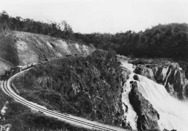
Early photos of the Kuranda to Myola settlements, during and after the Kuranda Railway construction, depict the deforestation and consequent landslides that usually occurred during heavy rainfall (sources: TROVE and Cairns Historical Museum - see Bibliography).
Picture
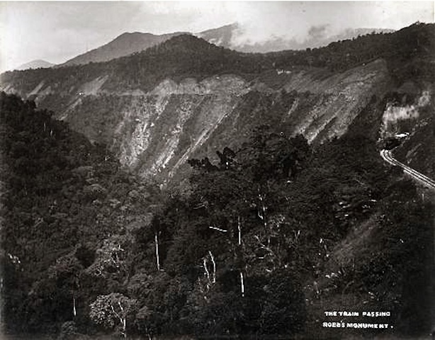
1890 - Excavations for the Kuranda Railway caused massive slips that often took months to clear and restore the line. Even so, by 1891, the railway was finished to Kuranda and the Kuranda railway station opened in June 1891
Picture
1890 - Thousands of men, as well as their families living on site, constructed the railway by hand. Much of the timber was used for sleepers, fuel for cooking and building material for the workers’ shelters.
Picture
1902 - Kuranda Railway arcs the Barron Falls before the weir wall was erected in 1963 to divert water to the hydroelectric power station (see Olds 2008)

Picture
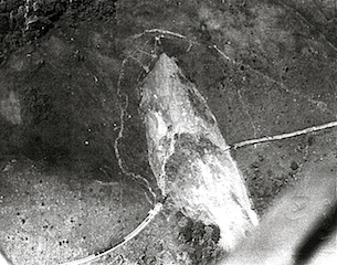
1954 A massive landslip probably caused by deforestation and heavy rain.
Picture
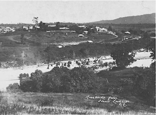
1906 Kuranda Village taken from Street’s coffee plantation. The white section in the middle is the sandy beach of the Barron River before the weir was erected.
Picture
Owens Creek bridge near Mantaka, circa unknown
To go to the post-colonial history page click here.
Back to previous page click here. 
Phone
​07 4093 8989

​Email
​info@envirocare.org.au


Write
PO Box 494 Kuranda 4881


Nursery Address 
284 Myola Rd, Myola , Kuranda 4881
beyond the Kuranda Aquatic centre

Nursery Opening Times
Monday & Thursday 9am - noon 
Saturday 10am - noon 
or ph. 0419 624 940 for appointment
    Subscribe to our newsletter
Subscribe

Newsletter Archive
Check out all previous monthly and biannual newsletters 
Newsletter Archive
  • Home
  • About us
  • Projects
    • Frog Habitat Project
    • Frog logo and T shirt competiton winners
    • Connecting Corridors Project
    • Bird Monitoring Project
    • Frog Monitoring Project >
      • Frog Friendly Neighbourhood
    • Yellow Crazy Ant Taskforce
    • GROW Project 1
  • Nursery
    • Naturally native plant collections
  • Get involved
  • Contact
  • Shop
    • Sizing and Product desc
    • Men's T-Shirts Leaf Design
    • Men's T-Shirts Scroll Design
    • Women's T-Shirts Leaf Design
    • Women's T-Shirts Scroll Design
    • Shipping T-shirts
  • Regional planning
    • Land development history
    • Kurworld >
      • TOO BIG
      • WRONG PLACE
      • NOT ENOUGH WATER TOO MUCH WASTE
      • ROAD CONGESTION
      • EMPTY PROMISES
      • NO TRUST
      • KEC Position
      • Resources
      • Submission Form
  • Invasive species
  • Local threatened species
  • Newsletter Archive
  • Membership
    • Membership benefits >
      • Library
  • Citizen science blog
  • Shipping T-shirts